


Roztocky okruh

SityTrail - itinéraires balisés pédestres
Tous les sentiers balisés d’Europe GUIDE+
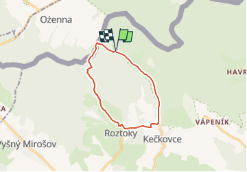

Length
9.5 km

Max alt
611 m

Uphill gradient
267 m
Km-Effort
13.1 km

Min alt
373 m

Downhill gradient
268 m
Boucle
Yes

Signpost
Creation date :
2022-02-16 16:38:18.894
Updated on :
2022-02-16 16:38:18.894
2h58
Difficulty : Easy

FREE GPS app for hiking
 SityTrail
IGN / Geographical institutes
SityTrail Plus
The world is yours!
About
Trail On foot of 9.5 km to be discovered at Region of Prešov, Unknown, District of Svidník. This trail is proposed by SityTrail - itinéraires balisés pédestres.
Description
Trail created by KST.
Positioning
Country:
Slovakia
Region :
Region of Prešov
Department/Province :
Unknown
Municipality :
District of Svidník
Location:
Roztoky
Start:(Dec)
Start:(UTM)
535598 ; 5473961 (34U) N.
Comments